Cities in Japan:
A Card-based Exploration of Urban Planning and Development
 |
Hari Srinivas |
|
Continuing Research Series E-258
|
Abstract:
This document presents a curated collection of thematic cards exploring key concepts, approaches, and practices in urban planning and development within the Japanese context. The cards provide concise, structured insights into governance, planning, sustainability, development, and future-oriented urban strategies.
Each card distills complex ideas into accessible formats, combining definitions, frameworks, and practical applications to support learning, teaching, and policy reflection. By situating global urban concepts within Japan's unique socio-spatial and institutional landscape, the collection offers a comparative and applied perspective on how cities can respond to contemporary challenges.
The card-based format encourages modular exploration, making it a useful resource for students, practitioners, and researchers interested in sustainable urban futures.
|
Keywords:
Japan, urban planning, urban development, sustainability, governance, urban policy, smart cities, urban futures
|
Japan's cities offer a rich and evolving landscape of urban planning and development, shaped by dense populations, limited land, advanced infrastructure, and a strong culture of coordination between government, industry, and communities. From transit-oriented development and compact city models to disaster resilience, aging demographics, and environmental sustainability, Japanese urban practices reflect both long-term planning traditions and continuous innovation. Japan's urban processes - as seen in the concepts, policies, and tools outlined in the cards - offer concise and structured insights into how cities in Japan are planned, managed, and reimagined for the future.
Urban planning in Japan is particularly defined by a unique "transit-first" philosophy where cities are built around high-density railway hubs rather than car-centric highways. Unlike the rigid, single-use zoning found in many Western countries, Japan employs a flexible, nationwide zoning system that encourages mixed-use neighborhoods, allowing houses, small shops, and light industry to coexist organically. This approach, combined with sophisticated land readjustment techniques and a constant focus on disaster resilience, creates hyper-efficient, walkable urban environments that remain functional even as the country navigates a shrinking and aging population.
This collection of 27 reference cards provides a structured overview of the institutions, legal frameworks, planning instruments, and emerging challenges shaping urban development in Japan.
 The cards are organised into five thematic clusters:
- Urban Governance and Institutions
- Urban Planning Systems and Regulations
- Urban Development Tools and Spatial Strategies
- Urban Sustainability and Infrastructure
- Urban Futures and Societal Change
Together, they offer a compact but comprehensive guide for students, researchers, and practitioners.
Overview of the Card Deck
The 27-card deck is organised into five thematic clusters that together provide a structured overview of how cities in Japan are governed, planned and managed.
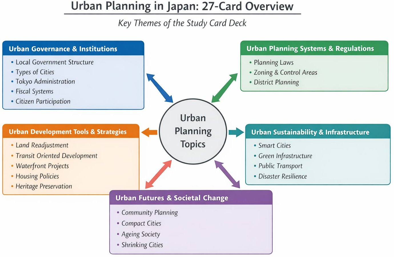 Figure 1: The Urban Cards Framework
- Urban Governance and Institutions, introduces the administrative and financial foundations of Japanese local government, including the structure of municipalities, types of cities, Tokyo's unique metropolitan system, fiscal arrangements and mechanisms for citizen participation.
- Urban Planning Systems and Regulations, explains the legal and institutional framework that guides urban development, including key planning laws, the main planning instruments, zoning regulations, the urbanisation control system and district level planning.
- Urban Development Tools and Spatial Strategies, focuses on the practical mechanisms used to shape urban space, such as land readjustment, transit oriented development, waterfront redevelopment and housing density policies, as well as broader metropolitan structures and heritage preservation.
- Urban Sustainability and Infrastructure, examines how Japanese cities address contemporary environmental and infrastructure challenges through sustainability initiatives, smart city technologies, green infrastructure, public transport systems and disaster resilience strategies.
- Urban Futures and Societal Change, highlights emerging urban challenges, including community based planning traditions, compact city policies, demographic ageing and population decline in regional cities. Together, these themes illustrate how Japan's urban planning system integrates governance, regulation, spatial planning and long term societal adaptation.
Index of Cards
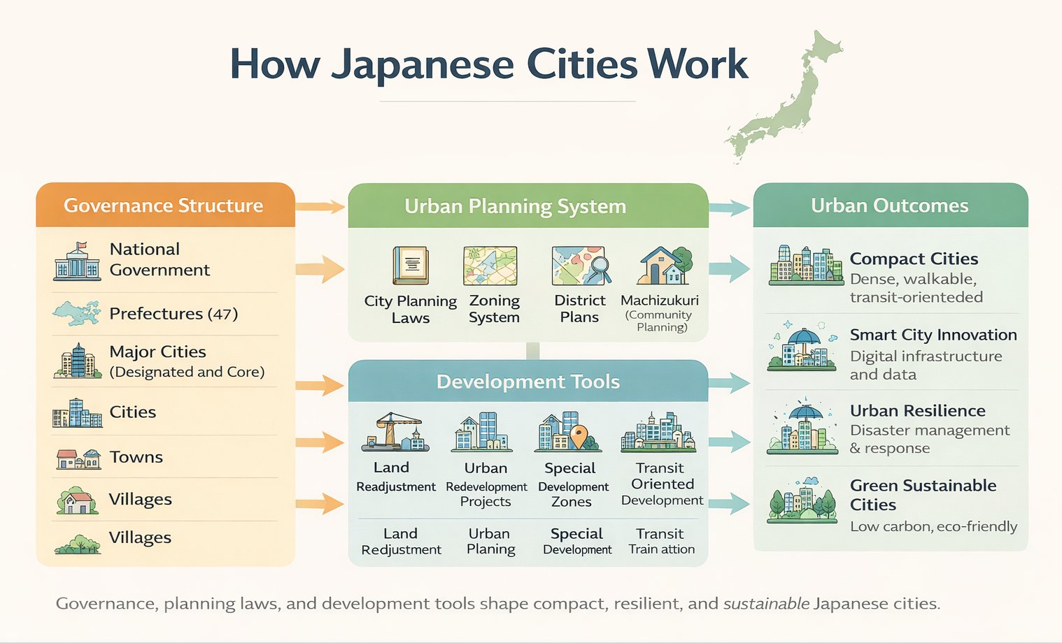 Figure 2: How Cities Work in JApan
Source: GDRC concept; diagram visualised with AI tools and edited by author
Figure 2: How Cities Work in JApan
Source: GDRC concept; diagram visualised with AI tools and edited by author
Figure 2 illustrates the functional framework of urban planning and governance in Japan, showcasing how different levels of government, planning systems, and development tools work together to create specific urban outcomes.
- Governance Structure: The system operates from the National Government down to local municipalities, including Prefectures (47), designated major cities, cities, towns, and villages.
- Urban Planning and Development: Local governance utilizes specific planning laws, zoning systems, and community-based plans (Machizukuri) to shape land use.
- Urban Outcomes: These efforts aim to create compact, walkable cities, implement smart technology, enhance urban resilience against disasters, and promote environmental sustainability.
I. Urban Governance and Institutions
Structure of Local Government in Japan
| Level |
Japanese Term |
English Equivalent |
Example |
| National |
Kuni |
National Government |
Government of Japan |
| Prefecture |
Todofuken |
Prefectural Government |
Kyoto Prefecture |
| Designated City |
Seirei Shitei Toshi |
Large city with expanded authority |
Kobe |
| City |
Shi |
Standard municipality |
Nara City |
| Town |
Cho or Machi |
Small municipality |
Kumano Town |
| Village |
Son or Mura |
Rural municipality |
Ogimi Village |
Types of Cities in Japan
| Type |
Criteria |
Governance Feature |
Example |
| Designated City |
Population above about 500,000 |
Subdivided into wards and given powers similar to prefectures |
Kobe |
| Core City |
Population above about 300,000 |
Delegated administrative functions |
Kanazawa |
| Special Ward |
Unique to Tokyo |
Functions similar to cities |
Shibuya |
| Ordinary City |
Standard municipality |
Regular municipal administration |
Nara |
Administrative Structure of Tokyo
| Level |
Institution |
Function |
| Metropolitan Government |
Tokyo Metropolitan Government |
Combines prefectural and metropolitan roles |
| Special Wards |
23 Tokyo Wards |
Function similar to cities |
| Cities |
Municipal cities in western Tokyo |
Standard municipal governments |
| Towns and Villages |
Smaller municipalities |
Local administration in rural Tokyo areas |
Fiscal Structure of Local Governments
| Revenue Source |
Description |
Example |
| Local Taxes |
Taxes collected directly by local governments |
Property tax, resident tax |
| Intergovernmental Transfers |
Financial transfers from national government |
Local Allocation Tax |
| Local Bonds |
Borrowing by local governments for infrastructure |
Municipal bonds |
| Service Fees and Charges |
Payments for local services and facilities |
Waste collection fees |
Citizen Participation
| Mechanism |
Description |
Example |
| Public consultations |
Citizens provide input during planning processes |
Urban planning hearings |
| Machizukuri initiatives |
Community led neighbourhood planning |
Kyoto community planning groups |
| Citizen advisory councils |
Residents advise municipal governments |
Local planning committees |
| Participatory activities |
Workshops and public meetings |
Community redevelopment discussions |
II. Urban Planning Systems and Regulations
Key Urban Planning Laws
| Law |
Year |
Main Focus |
| City Planning Law |
1968 |
Overall planning framework |
| Building Standards Law |
1950 |
Building safety and construction |
| Landscape Law |
2004 |
Protection of scenic landscapes |
| Urban Renaissance Law |
2002 |
Urban redevelopment and revitalisation |
Main Urban Planning Instruments
| Instrument |
Purpose |
Authority |
| City Planning Areas |
Defines planning jurisdiction |
Prefecture |
| Zoning System |
Controls land use and density |
Municipality |
| District Plans |
Detailed neighborhood planning |
Municipality |
| Urban Redevelopment Projects |
Renewal of built up areas |
Public private partnership |
Zoning System
| Zone Type |
Main Purpose |
Example |
| Residential Zones |
Protect living environments |
Low rise residential areas |
| Commercial Zones |
Concentrate retail and business activity |
City centre districts |
| Industrial Zones |
Support manufacturing and logistics |
Port industrial areas |
| Mixed Use Zones |
Allow multiple urban functions |
Station area development |
Urbanisation Control System
| Area Type |
Purpose |
Characteristics |
| Urbanization Promotion Area |
Encourage urban development |
Infrastructure investment and planned growth |
| Urbanization Control Area |
Restrict new development |
Agricultural and rural land protection |
| City Planning Area |
Overall planning jurisdiction |
Managed by prefectures |
| Development Permission System |
Controls land development activities |
Approval required for large projects |
District Planning System
| Element |
Description |
Example |
| Land use control |
Specifies permitted uses in a district |
Residential neighbourhoods |
| Building form guidelines |
Controls building height and layout |
Traditional townscapes |
| Public space planning |
Organises streets and open spaces |
Neighbourhood parks |
| Community involvement |
Residents participate in shaping plans |
Machizukuri based planning |
III. Urban Development Tools and Spatial Strategies
Urban Development Tools
| Tool |
Description |
Example Use |
| Land Readjustment |
Reorganisation of land parcels to improve infrastructure |
Post disaster reconstruction |
| Urban Redevelopment Projects |
High density redevelopment in built up areas |
Station area development |
| District Planning |
Fine grained local planning |
Residential neighbourhood design |
| Special Development Zones |
Incentive based development |
Central business districts |
Land Readjustment
| Feature |
Description |
Example |
| Land pooling |
Landowners temporarily combine land parcels |
Urban expansion areas |
| Infrastructure development |
Roads and services installed |
New suburban districts |
| Reallocation |
Smaller serviced plots returned to owners |
Residential neighbourhoods |
| Value capture |
Increased land value helps finance development |
Urban expansion projects |
Transit Oriented Development
| Feature |
Description |
Example |
| Railway centred development |
Private railway companies shape urban growth |
Tokyu Corporation developments |
| Station area planning |
Commercial hubs around rail stations |
Shinjuku |
| Mixed use development |
Retail, housing and offices integrated |
Yokohama |
| High transit accessibility |
Dense rail network supports compact cities |
Tokyo metropolitan region |
Metropolitan Regions
| Region |
Characteristics |
Major Cities |
| Tokyo Metropolitan Region |
Largest metropolitan area in the world |
Tokyo, Yokohama |
| Kansai Region |
Historic and economic centre |
Osaka, Kyoto, Kobe |
| Chukyo Region |
Manufacturing hub |
Nagoya |
| Fukuoka Region |
Gateway to Asia |
Fukuoka |
Waterfront Redevelopment
| Feature |
Purpose |
Example |
| Mixed use redevelopment |
Combine housing, offices, retail and leisure |
Yokohama Minato Mirai |
| Public open space |
Create accessible waterfront parks and promenades |
Kobe Harborland |
| Tourism and cultural attractions |
Revitalise former port areas |
Odaiba Tokyo |
| Economic revitalisation |
Attract investment and new industries |
Osaka waterfront redevelopment |
Housing Policy and Density
| Policy Tool |
Objective |
Example |
| Zoning regulations |
Control land use and building density |
Urban zoning districts |
| Public housing programmes |
Provide affordable housing |
UR Urban Renaissance Agency |
| Compact city planning |
Encourage dense development near transit |
Toyama compact city policy |
| Redevelopment projects |
Replace ageing housing with modern high density housing |
Tokyo redevelopment districts |
Urban Heritage Preservation
| Approach |
Purpose |
Example |
| Historic district designation |
Protect traditional urban areas |
Kyoto preservation districts |
| Cultural property protection |
Safeguard historic buildings and sites |
Nara heritage sites |
| Adaptive reuse |
Reuse historic buildings for modern functions |
Warehouses in Yokohama |
| Landscape preservation |
Maintain historic townscapes |
Kanazawa historic areas |
IV. Urban Sustainability and Infrastructure
Urban Sustainability Initiatives
| Initiative |
Focus |
Example City |
| Eco Model Cities |
Low carbon development |
Yokohama |
| Smart Cities |
Digital infrastructure and services |
Kashiwa no ha |
| Compact Cities |
Transit oriented urban form |
Toyama |
| Urban Green Infrastructure |
Parks and ecological networks |
Kobe |
Smart Cities in Japan
| Component |
Description |
Example |
| Smart Energy Systems |
Integration of renewable energy, smart grids and energy management |
Yokohama Smart City Project |
| Smart Mobility |
Data driven traffic management and mobility services |
Toyota Woven City |
| Digital Governance |
ICT platforms for urban services and citizen engagement |
Fukuoka Smart City initiatives |
| Urban Data Platforms |
Integration of real time urban data for planning and services |
Kashiwa no ha Smart City |
Green Infrastructure
| Element |
Function |
Example |
| Urban parks |
Recreation and ecological habitat |
Ueno Park Tokyo |
| Green corridors |
Connect ecological spaces across the city |
River greenways |
| Urban forests |
Improve climate resilience and air quality |
Miyawaki urban forests |
| Green roofs and walls |
Reduce heat island effects |
Tokyo metropolitan buildings |
Public Transport Systems
| Mode |
Characteristics |
Example |
| Urban railways |
Extensive and high frequency networks |
Tokyo Metro |
| Private railway companies |
Integrated rail, retail and real estate development |
Tokyu Corporation |
| Bus networks |
Local accessibility within cities |
Kyoto city buses |
| Light rail systems |
Revitalisation of urban transit in smaller cities |
Toyama LRT |
Urban Disaster Resilience
| Strategy |
Purpose |
Example |
| Earthquake resistant infrastructure |
Reduce damage during earthquakes |
Kobe reconstruction standards |
| Multi layer disaster planning |
Preparedness at national, prefectural and municipal levels |
Disaster prevention plans |
| Community preparedness |
Local disaster drills and volunteer groups |
Neighbourhood disaster associations |
| Early warning systems |
Rapid alerts for earthquakes and tsunamis |
Nationwide J-Alert system |
V. Urban Futures and Societal Change
Machizukuri
| Concept |
Description |
Example |
| Machizukuri |
Community driven urban planning and local development |
Widely used in Kyoto |
| Citizen participation |
Residents involved in planning discussions |
Neighbourhood workshops |
| Local planning councils |
Community advisory bodies |
District committees |
| Collaborative governance |
Government and residents jointly shape projects |
Redevelopment projects |
Compact City Policies
| Policy |
Objective |
Example |
| Urban consolidation |
Reduce urban sprawl |
Toyama |
| Transit oriented living |
Concentrate development near transit |
Toyama LRT |
| Age friendly cities |
Support ageing population |
Local service hubs |
| Efficient infrastructure |
Reduce infrastructure costs |
Dense urban centres |
Ageing Society and Planning
| Planning Approach |
Purpose |
Example |
| Barrier free urban design |
Improve accessibility for elderly residents |
Elevators in train stations |
| Compact city policies |
Concentrate services near residential areas |
Toyama compact city strategy |
| Neighbourhood service hubs |
Provide healthcare and daily services locally |
Community care centres |
| Accessible public transport |
Ensure mobility for ageing populations |
Low floor buses and accessible stations |
Shrinking Cities
| Strategy |
Objective |
Example |
| Urban consolidation |
Concentrate population and services |
Compact city policies |
| Downtown revitalisation |
Revive declining city centres |
Local redevelopment projects |
| Vacant land reuse |
Convert unused land for community uses |
Urban agriculture or parks |
| Public transport strengthening |
Maintain accessibility despite population decline |
Light rail systems in regional cities |
Regional Revitalisation
| Strategy |
Role |
Example |
| Rail investment |
Connectivity |
Regional lines |
| LRT systems |
Revitalisation |
Toyama |
| Station hubs |
Local economy |
Town centres |
| Accessibility |
Retain population |
Regional cities |
This collection of cards offers a window into the evolving landscape of urban planning and development in Japan, highlighting both enduring principles and emerging innovations. While grounded in the Japanese context, many of the ideas presented here have wider relevance, offering insights for cities navigating similar challenges around the world. Readers are encouraged to explore the cards as building blocks for learning, teaching, and practice, and to reflect on how these approaches can be adapted, contextualized, and applied in different urban settings.
Suggestions for new cards to be added to this collection are welcome! Please send an email to the address listed below.
|

